
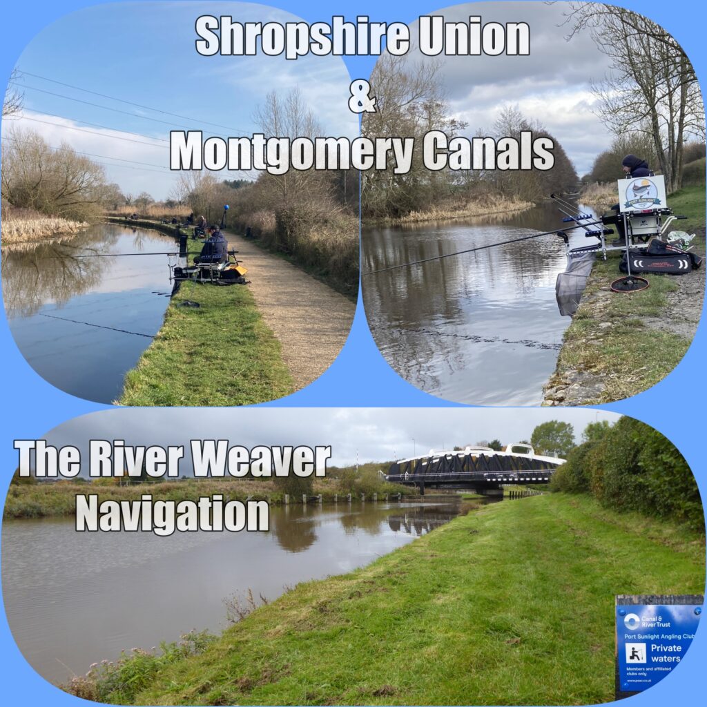
We now offer an annual canal permit at £15 together with an annual Junior permit free of charge for juniors up to the age of 16
Below are copies of maps showing the stretches that can be fished with the Annual Canal Permit. Details of any additional stretches that may become available will be sent to permit holders by email with a map and details.
If you would like to purchase a permit visit http://portsunlightanglingclub.clubmate.co.uk/register
When completing your registration you must make sure that your details are completed in full and a clear head and shoulders photo of yourself (No posing with fish please) is uploaded before you can purchase your permit.
The Permit runs for 12 months from the date purchased. Permit Holders can also take part in published Canal Matches.
Fishing is by rod and line/pole only. No fish to be removed from the fishery, under any circumstances.
Not more than six fish within legal size limits to be taken and used as livebaits on the fishery in any one day. No livebaits are to be brought onto site or removed from the fishery.
This permit is separate from our usual membership plans and has none of the privileges afforded to full membership.
Shropshire Union Canal Christleton between Rowton Bridge to Greenfield Lock
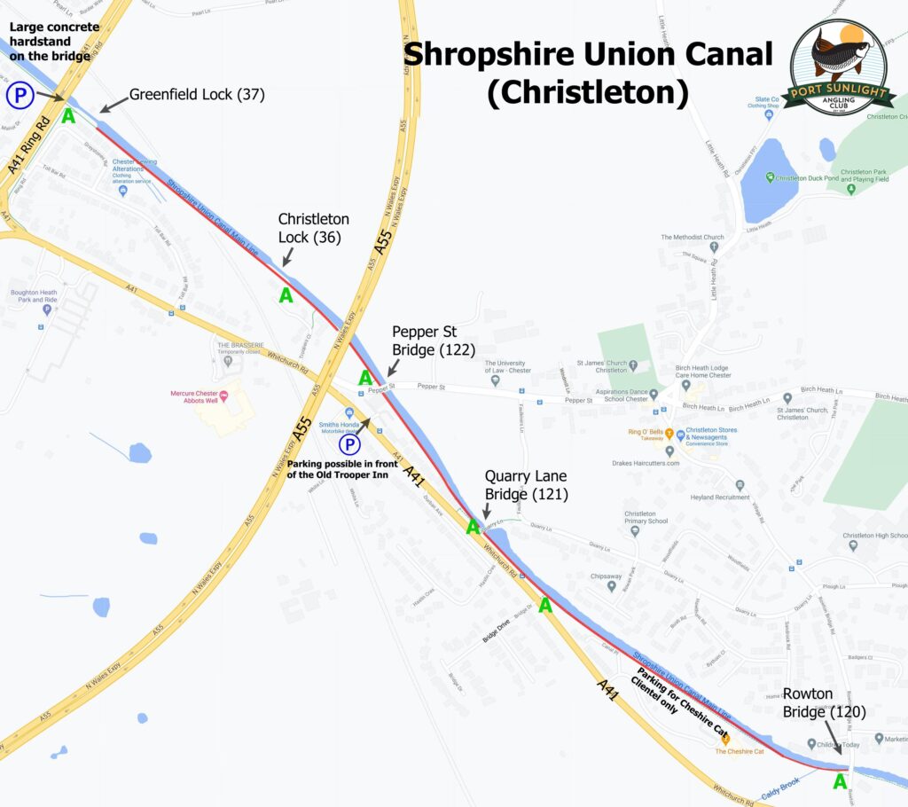
Fishing Rights (In red)
P Parking
A Access Points
This stretch of the Shropshire Union Canal runs alongside the A41 (Whitchurch Road, Christleton) from the A41 ring
road bridge as far as Rowton Bridge past the Cheshire Cat Public House. With fishing on the stretch under the direct
control of PSAC.
Parking is available on a concrete hard pad on the A41 Ring Road bridge, and in Bridge Drive. If you choose to park in
Bridge Drive, please park sensibly as this is a residential road. No Parking in the Cheshire Cat car park. Parking is for
Patrons only.
There are various access points to the tow path along its length marked A
A41 Ring road Bridge – ///valley.cube.busy
Bridge Drive – ///indoor.loves.allows
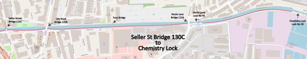
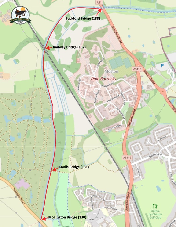
Shropshire Union Canal Mollington Bridge (130) to Chemistry Lock (inc. Telford’s Basin and the Dee Branch)
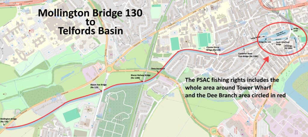
Shropshire Union Canal
Mollington Bridge (130) to Backford Bridge (133)
Fishing Rights (In red)
Parking is available in the layby on the left approx. 150m before Mollington Bridge
What three words ///events.activism.kite
Shropshire Union Canal – Backford Bridge to Croughton Bridge
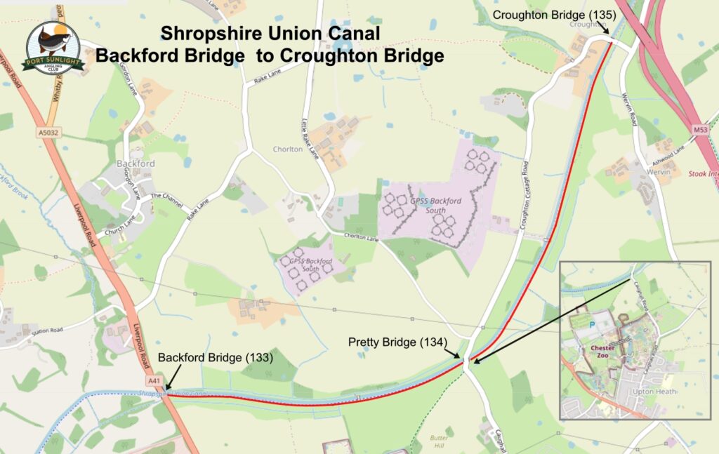
Fishing Rights (in red)
P Parking
The middle of this stretch is Pretty Bridge (134) where Caughall Road crosses the canal and stretches to the left of
the bridge to Backford Bridge (133) where the A41 crosses over the Canal and to the left of Pretty Bridge as far as
Croughton Bridge (135) where Wervin Road that branches off to the left just before going under the motorway
crosses the canal.
Parking is available at the side of Wervin Road just before Croughton Bridge with similar parking available at the side
of Claughall Road at Pretty Bridge.
Post code for Pretty Bridge is CH2 4BG
Pretty Bridge – ///brings.clubs.keen
Croughton Bridge – ///power.clustered.armful
Shropshire Union Canal – Croughton Bridge to Meadow Lane Bridge No139
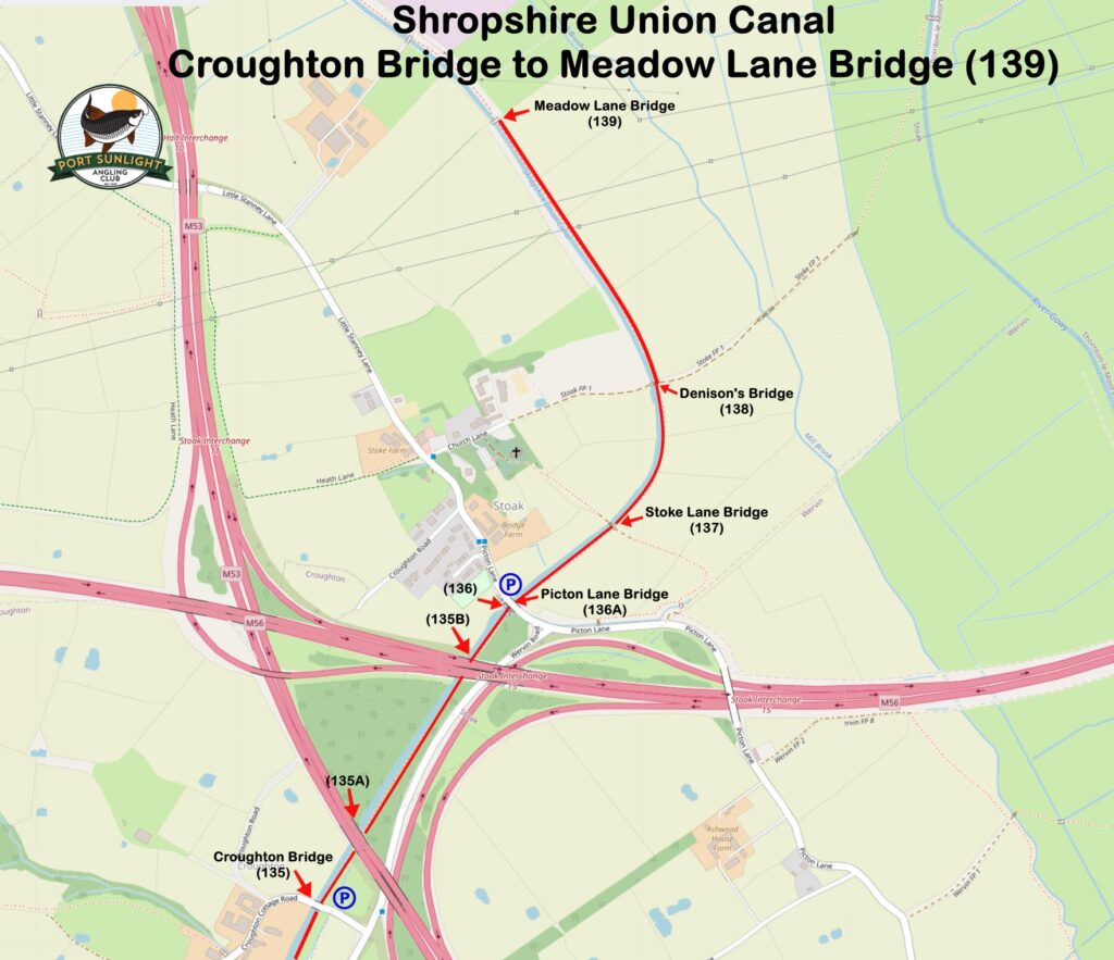
Fishing Rights (In red)
P Parking
This water is the continuation of the Shropshire Union Canal at the end of the Backford
stretch from Croughton Bridge No 135 to Meadow Lane Bridge 139.
Parking is available at Croughton Bridge (135) where Wervin Road that branches off to the
left just before going under the motorway that crosses the canal and also at Picton Lane
Bridge (136A) and would suggest that members check out the area themselves to identify
additional parking along the length.
Croughton Lane Bridge – ///power.clustered.armful
Picton Lane Bridge – ///quarrel.bravo.hooked
Shropshire Union Canal – Meadow Lane Bridge No139 to New Road Bridge No 148
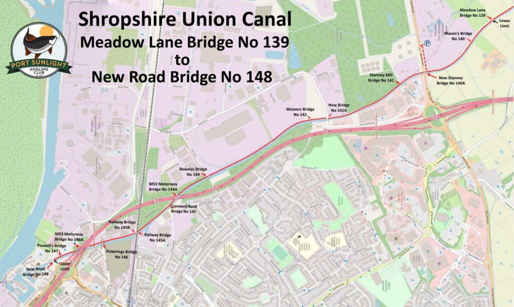
This is a continuation of our Croughton Bridge Stretch starting at Meadow Lane Bridge No139 and ending at New Road Bridge No148 (Oil Sites Rd)
There is decent parking on the A5117 (Hill View Way) with easy access to the tow path around New Stanney Bridge No140. ///slam.winter.wisely
Please respect the no fishing signs relating to overhead power lines
The Mongomery Canal – between Oswestry Bypass Bridge (A5) No.76A and Graham Palmer Lock where the Dee Anglers stretch at Lower Frankton begins.
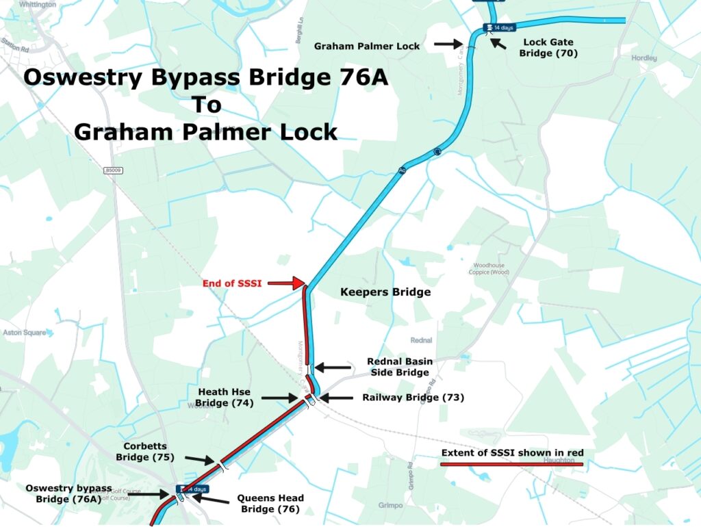
Special Conditions
There are special conditions to abide by on this stretch in particular the stretch from Oswestry Bypass and Keepers bridge is a Site of Special Scientific Interest (SSSI) and therefore has a Fishing Closed Season between 15th March and 15th June (Both dates Inclusive) which must be strictly observed. A pdf version of the map can be found HERE
Weaver Navigation (Sutton Weaver)
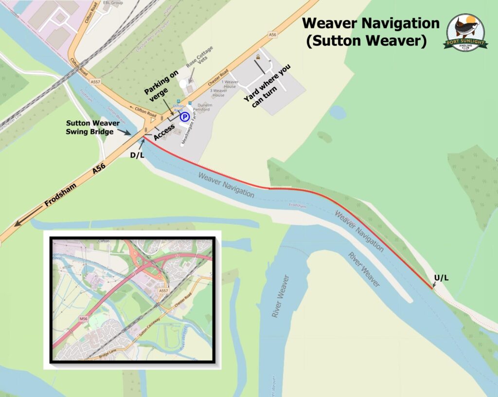
This stretch of the Weaver Navigation starts from where the A56 crosses the Navigation at the Sutton Weaver Swing
Bridge between Sutton Weaver and Frodsham up stream for about 720 metres. Fishing on this stretch is under the
direct control of PSAC.
Parking is available on the verge just before the junction of the A557 on the A56 which has a dropped curb at the
start. When arriving from the A557 (Clifton Road) turn left on to the A56 then right into the yard at the car wash
where you can turn and approach the verge in the right direction. The nearest post code is WA7 3GF.
The river here is deep and wide with a good head of coarse fish including Carp, Bream, Pike, Eels, as well as mixed silvers.
Fishing Closed Season 15th March to 15th June Both dates inclusive
///crackling.alley.stupidly
The small print
The small print.
In addition to our club rules Club Members and Permit Holders must:
- Utilise only such means of access to and egress from the Permitted Length along the towing path of the Waterway or other specified route as may be agreed from time to time by the Trust’s Fisheries Representative.
- Produce for inspection, membership cards or authorisations at the request of any Trust staff and comply with any reasonable directions given by Trust Staff.
- Only fish using rod and line, including pole fishing; any other equipment is expressly prohibited.
- Comply with the following:
- The Trust’s “Better Towpaths for Everyone” policy
- The Trust’s Byelaws for the time being in force.
- The “Check Clean and Dry” campaign.
- The “Waterway Code for Anglers and Boaters”
(All of which are available on the CRT website canalrivertrust.org.uk)
In addition to our club bylaws Club Members and Permitted Users must not:
- Unreasonably obstruct or impede navigation on the Waterway.
- Obstruct the mooring of craft at locations signed by the Trust as being for the purpose of mooring.
(For the avoidance of doubt fishing from vacant signed mooring locations is permitted when the mooring is not in use SAVE THAT the mooring location must be vacated if a craft arrives and reasonably wishes to moor.)
- Obstruct the passage of other legitimate users along the towing path on the permitted length.
- Interfere, cause or permit any interference with any works of the Trust or its contractors or with any craft plant or equipment on the waterway or the towing path
- Fish in a lock and/or within 25 metres of a lock wall approach or moveable bridge used for navigation.
- Fish within prohibited signed zones adjacent to overhead power lines.
- Trespass on any property adjoining the waterway and/or from causing unreasonable annoyance or inconvenience to the owners or occupiers thereof.
- Fish within 25 metres of a water point.
- Pollute the waterway or deposit litter or rubbish of any description (including discarded fishing tackle, bait, ground bait and line, and temporary peg numbers) either in the Waterway or on the towing path along any part of the permitted length and the Licensees will make arrangements to collect any angling-related litter and to dispose of it properly in accordance with law.
- Remove any fish or crayfish unless as required by the KIFR permit, Wildlife & Countryside Act 1981, and other legislation.